Geographic Information System is widely used for emergency reponse in developed world. I will show some of the highlights on my Geographic Information Systems project at the Federal School of Surveying , Oyo where the GIS serves as a tool for emergency response such as best route to the hospital, Alternate route to the hospital, closest facility, service areas.
**BACKGROUND OF THE STUDY**
Transportation is the movement of people, animals and goods from one location to another. Modes of transport include air, rail, road, water, cable, pipeline and space. The field can be divided into infrastructure, vehicles and operations. Transport is important because it enables trade between persons, which is essential for the development of civilizations.
Transport infrastructure consists of the fixed installations including roads, railways, airways, waterways, canals and pipelines and terminals such as airports, railway stations, bus stations, warehouses, trucking terminals, refueling depots (including fueling docks and fuel stations) and seaports. Terminals may be used both for interchange of passengers and cargo and for maintenance.
The specific purpose of transportation is to fulfill a demand for mobility, since transportation can only exist if it moves people, freight and information around. Otherwise it has no purpose.
Vehicles traveling on these networks may include automobiles, bicycles, buses, trains, trucks, people, helicopters, watercraft, spacecraft and aircraft. Operations deal with the way the vehicles are operated, and the procedures set for this purpose including financing, legalities and policies. In the transport industry, operations and ownership of infrastructure can be either public or private, depending on the country and mode.
Nigeria has the largest road network in West Africa and the second largest south of the Sahara, with roughly 108,000 km of surfaced roads in 1990.
However they are poorly maintained and are often cited as a cause for the country’s high rate of traffic fatalities. In 2004 Nigeria’s Federal Roads Maintenance Agency (FERMA) began to patch the 32,000-kilometre federal roads network, and in 2005 FERMA initiated a more substantial rehabilitation. The rainy season and poor equipment pose challenges to road maintenance.
Over 96% of physical distribution and movement of people and goods within the country are by the road mode. This over bearing dominance of the road mode has had a huge negative impact on the overall projected growth in agriculture, industries, solid mineral resources as well as spatial interaction of people across the nation and therefore requires immediate and urgent action. An important challenge of this dominance is a continuous high rate of fatality, due in part, to the road safety situations, despite the significant progress made by the Federal Road Safety Commission.
Roads are often built in comparatively undeveloped areas, which are not necessarily inhabited to stimulate their development and potential economic growth (Akinyele J.O 1990)
Geographic information systems are computer based to capture, stores, check, integrate, maintain, analyze and display geographic information which can be related to a specific location or portion on the earth surface. Spatial information covers a large range of decision-making and is capable of linking description of location with characteristics of the features found such as road the road network.
A network is a set of connected line features that form a pattern. Network of roads provides accessibility or easy movement of the resource or person from one location to the other on the earth surface. A road network consists of multiple connected lines and one of the Geographic Information System major strength is the ability to perform numerous operations on networks. Data acquisition for the road network can be accompanied by making use of remote sensing, digital photogrammetry, and also from secondary data sources. Non- spatial attributes data can also be acquired for the road network and existing facilities. The three core relationships and the impedance (friction) they are subject to are:
• Locations. The level of spatial accumulation of socio-economic activities jointly defines demand and where this demand is taking place. Impedance is mostly a function of the accessibility of nodes to the demand they service.
• Flows. The amount of traffic over the network, which is jointly a function of the demand and the capacity of the linkages to support them. Flows are mainly subject to the friction of space with distance being the most significant impedance factor.
• Terminals. The facilities enabling access to the network as terminals are jointly characterized by their nodality and the linkages that are radiated from them. The capacity of transport terminals to handle flows is the main impedance factor.
An emergency is a deviation from planned or expected behavior or a course of events that endangers or adversely affects people, property, or the environment.
Response refers to activities following an emergency or disaster. These activities are designed to provide emergency assistance for victims (for example, search and rescue operations). They also seek to stabilize the situation and reduce the probability of secondary damage to speed recovery operations.
This project will look at the concept of how to use GIS functionality to create digital spatial database for road network in responding to emergency services. Network analysis will help users to take decision on:
**- Efficient travel routes**
**- Quickest way to visit several locations**
**- Which facility is closest to accident scene
locations**
**- Which facility is closest to accident scene**
**STATEMENT OF PROBLEM**
Ile Ife has no digital road network which poses routing problems making the maintenance and administration of road a difficult task. The life and property of the inhabitants are endangered when there is an outbreak of emergency within a neigbourhood where there is poor accessibility of roads.
**- AIM AND OBJECTIVES**
**AIM**
The aim of this project is to create a digital road network for Ile Ife with a view to enhancing routing between facilities in the town.
**OBJECTIVES**
**The objectives of this project are listed below.
Database Design for the study area (Part of Ile Ife Town)
Acquisition of Geometric and Attribute data of the study area.
Database creation and linking attribute tables to geometric data.
Design a digital road network map.
Identifying accident prone positions in the study area.
Performing spatial analysis including network analysis to respond to emergency services.
**- SIGNIFICANCE OF STUDY**
The purpose and significance of the study is to develop a digital road network for emergency response to locate the closest Hospital to accident scene, to suggest shortest route from emergency spot to the recovery point, using network analysis and by mapping and monitoring of fire and road accidents for part of Ile Ife town using GIS application. It will be able to determine which hospital should respond to an emergency call using the network as an accumulated surface.
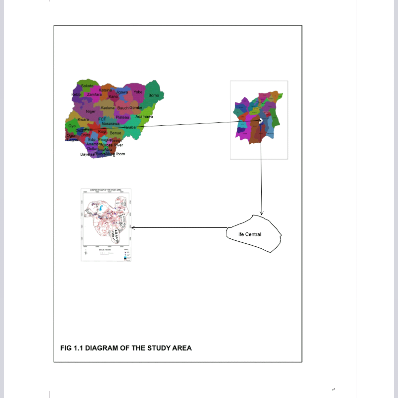
**- STUDY AREA**
Ile Ife is an ancient town in Yoruba history and is regarded as the cradle of civilization. According to Yoruba tradition, Ife is the ancestral and spiritual home for all Yoruba. It is believed that the creation of the world started from Ife. Hence, it is popularly referred to as “Land of the Source”
The Ooni of Ife is the traditional head and is highly revered amongst the Yoruba particularly and the nation in general.
Administratively, Ile-Ife has two local governments namely Ife Central and Ife East. The headquarters of Ife Central Local Government is on Ibadan Road while that of Ife East is at Oke-Ogbo. The projected population of the two according to National Population Commission is put at 190,254 and 220,027 respectively.
Geographically, Ile-Ife lies between 4023’ and 4037’ east longitude and 7028’ and 7040’ north latitude. The climate is tropical. Like every other Southwest area, the rainy season starts April to October while the dry season lasts October to March.
Ile-Ife is home to the prestigious Obafemi Awolowo University and other important places University Teaching Hospital Complex, Ife Museum of Antiquities, Opa Oranmiyan, Oke-mogun Shrine. The Olojo Festival, an important event in the ancient town holds annually
**CONCEPT OF NETWORK ANALYSIS**
**- NETWORK ANALYSIS**
These are set of interconnected line entities whose attributes share some common theme primarily related to flow. A network is made up of edges and nodes, Edges are the “lines” of the network and Nodes are physical locations.
**- NETWORK LINES**
These define relationships between nodes
**- NETWORK ANALYST**
This is a GIS extension that allows you to analytically interface networks (systems of lines and points. The tool’s features can help design efficient routes, determine service areas around a specific site (in terms of time and distance), and calculate the nearest facilities or vehicles.
**- ROUTE**
Finding driving directions between two points, Best route between stops “Best” can mean different things-Shortest distance -Quickest -Most scenic -No highway.
**- SERVICE AREAS**
calculates an area based on time or distance from an input
Good for estimating populations
Different than a simple buffer.
**- CLOSEST FACILITY**
Calculate the nearest X number of facilities to an incident or point of interest
Closest can be based on network distance or time
Set up a cutoff -Find all the hospitals within 5 minutes of an accident
**- SYSTEM SELECTION**
**- Hardware**
A complete desktop computer system is used with the following specifications:
- Intel core i3 PC Computer
- 500 GB Hard disk drive
- 4 GB RAM
- 15.6 HD Monitor
- Printer
- Digital Camera
- GARMIN etrex 10 Handheld GPS
- 3.4.2 Software
- ArcGIS 10.2.2
- Microsoft office 10
- Geo Cal
**- DATA DECLARATION**
In the course of this project, the tables created in the physical design stage of database have data types that were used to define them.
**- DATA CONVERSION**
The geometric data was captured by using Google Earth images as base map. Georeferencing was done using ArcGIS 10.2.2 software, on screen digitizing was carried out in ArcGIS 10.2.2 on roads, facilities and boundary layers.
**- DATABASE CREATION**
Having complete the stages of the database design phase (reality, conceptual, logical and physical) the database for this project was created using ArcGIS 10.2.2 (version) software. The base map was cropped from Google Earth and the major points on the map were identified. The coordinate values of the points on the map was used to geo-referenced the map. Each entity was set on as layers and digitized out separately and then populating the attribute table which was used to carry the analysis. In the ArcGIS 10.2.2 environment, theme in the menu bar was selected and table chosen, also edit was selected at the menu bar and fields was finally selected after which all available attribute names and data type were supplied.
**Stay tuned for **PART 2** which is the spatial analysis and
presentation**
**REFERENCES**
CEHI Children Environmental Health Initiative. NETWORK ANALYSIS TOOLS, GIS III: GIS Analysis.
Manfred M. Fischer Department of Economic Geography & Geoinformatics Vienna University of Economics and Business Administration Rossauer Lände 23/1 A-1090 Vienna, Austria. GIs and Network Analysis
An ESRI White Paper • May 2000. GIS Technology for Disasters and Emergency Management by Russ Johnson
Sedgwick County Sheriff’s Office Special Projects Unit July 9, 2008. Geographic Information Systems (GIS) and Emergency Management Pg 1- 7
Susan Mayhew (2004) Oxford Dictionary of Geography. Oxford University Press Inc, New York pg 220.
Uwe Deichmann, DECRG. March 30, 2007. Use of GIS in road sector analysis
Sagar P. Mali & Yogesh A. Mane, International Journal of Advanced Computer Technology (IJACT) NEtwork Analysis For Urban Emergency Services In Solapur City, India: A Geoinformatic Approach
Leonid V. Stoimenov, Member, IAENG, Aleksandar Lj. Milosavljević, and Aleksandar S.
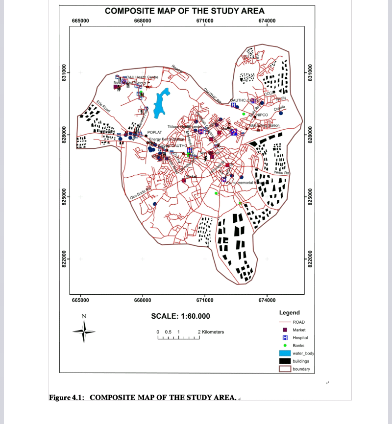
Road Neetwork Information System for Emeegency Response in Part of Ile Ife Town, Osun state.
All pictures were produced by @matthiasolusegun